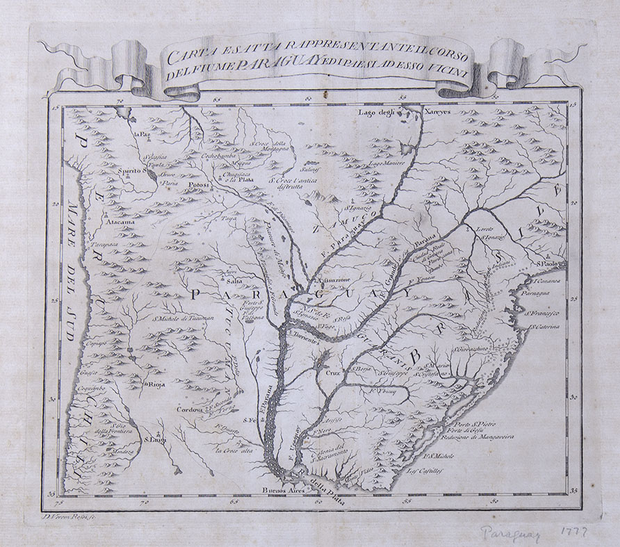
Carta Esatta Rappresentante il corso (...). 1763.
Carta Esatta Rappresentante il corso del Fiume Paraguay ed i paesi ad esso vicini. 1763.
Engraving on paper. Measures. Plate: 33.5 x 46.3 cm / 13.18 x 18.22 in. Paper: 24 x 27.8 cm / 9.44 x 10.94 in. Good copy. It is displayed framed.
It is a territorial strip -from coast to coast- that includes from South to North, the lands bathed by the Paraguay River. On the upper margin, you can see the cities of La Paz and Cochabamba, in Alto Perú, and on the Paraguayan territory, the Lago degli Xareyes, a site steeped in mysteries and fantasies. Its existence was linked from its location with El Dorado, being today identified as the Pantanal or Great Pantanal (it extends through Mato Grosso, Brazil, and includes Paraguay and Bolivia within its limits). From the time of the Spanish conquest it was part of the fantastic construction of its cartography. The first references allude to an indigenous people called Xaraye who inhabited this region located in the north of Paraguay. In these primitive documents they are mentioned as possessors of silver and gold, a reference that explains the power of that legend among the travelers of the time. Then the term became a place name. On the Atlantic coast, the cities of San Pablo to the North and Buenos Aires to the South are marked.
In the interior of the continent we locate the Iberá estuaries -without identifying its name-, the town of Corrientes -with a typographical error, indicated as Torrientes - and among many other geographical references, numerous Jesuit missions, such as San Borja, Cruz, Saint Ignatius and Saint Mary.
With a happy title for its promotion, this "Exact chart representing the course of the Paraguay River and its neighboring countries" was made by Veremondo Rossi (1720 - 1778) and was part of the Gazzettiere americano contenente un distinto ragguaglio di tutte le parti del nuovo mondo della loro situazione, clima, terreno, prodotti, stato antico e moderno, merci, manifatture, e commercio. Con una esatta descrizione delle città, piazze, porti baie, fiumi, laghi, montagne, passi, e fortificazioni. Il tutto destinato ad esporre lo stato presente delle cose in quella parte di globo, e le mire, e interessi delle diverse Potenze, che hanno degli stabilimenti in America. (...). Another version edited by Masi is known (Livorno, 1777).
DBM
| AUTHOR | ROSSI, VEREMONDO |
|---|
Are you interested in selling some works?
Send us an email briefly indicating
which works you intend to put on sale, and we will respond. click here
Subscribe to our newsletter to be updated.
Check our Newsletters